The Overconfidence Trap: Why Better Hiking Tech Is Making People Less Safe

Let's talk about what these apps are actually doing.
Not what the marketing says they do. What the incident reports say.
Washington State Search & Rescue annual reports document a steady climb in incidents over the past several years—a trend that runs parallel to the explosive growth in hiking app adoption. AllTrails crossed 50 million registered users globally, by their own public statements, as of 2023. App downloads spike every March when people start planning spring hikes. Rescue call volume trends the same direction.
I'm not saying correlation is causation. I'm saying the industry claims the technology is making people safer, and the trend data doesn't support that claim. As someone who spent a decade moving freight across the Pacific Northwest with zero margin for miscalculation, I know what happens when you confuse a better tool with a better decision.
The Tool Paradox
Here's a principle from logistics: the easier you make a process, the more mistakes you catch per unit—not because people are worse at their jobs, but because lower barriers mean more people attempt the task who shouldn't be attempting it yet.
The same thing is happening in the Cascades.
Multiple outdoor industry surveys over the past three years document a sustained post-pandemic surge in first-time hikers. The consistent finding: navigation apps rank among the primary reasons new hikers felt confident enough to attempt trails they otherwise wouldn't have. That's the data the industry leads with. What they don't lead with: Cascade Rescue Operation's spring incident reports consistently describe rescues involving hikers who were adequately equipped with technology—phones charged, GPS downloaded, offline maps loaded—and still ended up requiring extraction.
The barrier that dropped wasn't the terrain. It was the perceived risk. And those are not the same thing.
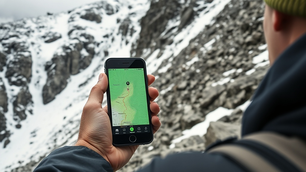
The Rating System Problem
Pull up any trail on AllTrails rated "Moderate" in the Cascades this spring. Look at what the rating is actually based on.
Based on AllTrails' publicly documented methodology, difficulty ratings weight distance, elevation gain, and crowd-sourced user input. What that means in practice: the system is not built to capture the factors that determine your actual risk on Cascade terrain in April and May.
It does not account for:
- Scramble class (Class 2–3 sections that require hands and route-finding)
- Seasonal snow coverage on north-facing slopes in April and May
- Stream crossings that go from ankle-deep in August to waist-deep in May
- Exposure on ridge traverses where wind and weather change the risk profile entirely
- The gap between where the trail appears on the map and where it actually is after a winter of blowdowns
Last spring, trip reports and ranger district logs documented incidents on North Cascades trails rated "Moderate" where hikers encountered Class 2–3 scramble sections under consolidated spring snow—terrain the app showed as a clean ridgeline. The scramble isn't hard in August. In May, with a foot or more of snow covering the handholds, it's a different situation entirely. The app's rating didn't update. The terrain did.
User-generated ratings average out the extremes. A trail that's a pleasant walk in July and a genuine hazard in April averages to "Moderate." The system optimizes for aggregate satisfaction across all seasons, not your specific safety window in a specific month.
I've written more about how AllTrails fails on Cascades terrain—this problem isn't new, and it's worsening as more unprepared hikers follow the star ratings into conditions they can't assess.
The False Safety Promise
GPS doesn't assess your fitness. It doesn't know your experience on snow. It doesn't know you've been hiking for six months and have never been above treeline. It gives you a line on a map and tells you where you are relative to that line.
I've heard the counter-argument: "At least people know where they are now." Fine. Tell that to parties that have gotten pinned by weather on Rainier approaches—they knew exactly where they were. What they couldn't assess was whether the next two hours of terrain was within their margin. No app makes that assessment. No app can.
What technology is actually doing is removing the steps where judgment gets built.
When I was running logistics for Pacific Northwest freight routes, I had coordinators who learned the job by calling ahead, asking questions, building mental models of the route before the truck left the yard. They learned to anticipate problems because they were forced to think through the sequence before it happened. Then we got route optimization software. The new coordinators could generate a route in 30 seconds without understanding why the route was built that way. When the software gave them a bad route—and it did, regularly—they had no framework for recognizing it.
That's what's happening with trail apps. The pre-trip research process—the part where you're reading trip reports, calling the ranger district, checking NWAC, triangulating conditions across multiple sources—that's where judgment develops. That's where you build the mental model that tells you when to turn around. Apps shortcut that process. And then they put you on the trail.
What the Rescue Data Actually Shows
The Mount Rainier National Park climbing incident reports tell a consistent story: the majority of rescues do not involve gear failure or freak accidents. They involve parties that exceeded their margin—went too far, too late, in conditions they misread, with a skill level below what the terrain required.
The Cascade Rescue Operation publishes debrief summaries. Read enough of them and a pattern emerges: "Party was unaware the route involved technical terrain." "Party did not account for afternoon snow conditions." "Party did not have a turn-around time established."
An app didn't cause any of those decisions. But an app lowered the activation energy for getting onto terrain where those decisions became critical.
Wilderness permit usage data for popular Cascade trailheads shows meaningful increases in the spring shoulder season compared to pre-pandemic baselines—a pattern documented in USFS ranger district annual recreation reports. The March trap—when spring's arrival makes terrain more dangerous while appearing more approachable—is when this collision happens most dramatically. What that trend looks like from the ground isn't experienced hikers accessing the backcountry more efficiently. It's the entry-level population expanding rapidly into terrain that historically filtered for experience through friction—difficult research, harder permit systems, less accessible trailheads.
The friction wasn't an accident. Some of it was bureaucratic inefficiency, sure. But some of it was natural selection for people who cared enough to do the work.
What Actually Prevents Injuries
Not apps. Not gadgets. Here's what the rescue data points to when things go right:
Written trip plan with a named contact. Someone who knows where you're going, what time you're expected back, and what to do if they don't hear from you. This is logistics 101. You don't move a truck without a route plan and a check-in protocol. You shouldn't move up a ridge without one either.
Permit deadlines as hard constraints. If the permit says be off the summit by noon, that's an abort trigger. Not a suggestion. I don't care how good the summit looks at 11:45. That deadline exists because afternoon conditions are systematically worse. It was built from incident data.
Time budgets per mile. Vertical gain matters more than distance. A mile at 500 feet of gain is a different problem than a mile at 1,500 feet of gain. Know which you're on and budget accordingly. Build in the buffer. Experienced Cascades hikers typically plan for 30–50% longer than their best-case pace.
Abort criteria established before you leave. Not on the trail. Before you leave. "If we're not at the ridgeline by 10 AM, we turn around." Write it down. Tell your partner. This is the hardest thing to do because it requires honesty about your actual speed and capability, not your aspirational speed and capability.
Condition verification from multiple sources. Not just the app. Call the ranger district. Check the NWAC forecast. Read the most recent trip reports on the actual hiking forums—not the star ratings. If three sources are telling you something different, figure out why before you go.
Partner accountability with explicit skill floor. Who is the weakest technical member of your party on this specific terrain? That person sets the pace and determines the difficulty ceiling. Not the strongest. Not the most enthusiastic. The person who is most likely to be at their limit.
Complacency is the real threat—the rescue data bears this out consistently. None of this requires an app. All of it requires thinking before you go.
The Checklist the Apps Won't Give You
I'm going to give you the framework I use. It's not glamorous. It's not shareable content. It's what actually works.
Before you book the permit:
- What is the Class rating of the terrain, not the trail difficulty? (Look it up in actual guidebooks, not the app.)
- What are the typical conditions for this trail in this month? (Ranger district website, not the app.)
- What is the failure mode? (What happens if someone in your party can't complete the route?)
Before you leave the trailhead:
- Is your trip plan filed with a named contact who has instructions?
- Do you have a written turn-around time?
- Does every member of your party know the abort criteria?
- Have you checked the weather window for the specific elevation band you'll be in, not just the trailhead?
- What is your actual pace on comparable terrain? Not your best day—your average day.
On trail:
- Are you on pace for your time budget at each checkpoint?
- Has anything changed (weather, party condition, route conditions) that would trigger your abort criteria?
- Is anyone managing morale over safety?
The last one matters. Sunk cost thinking kills people in the mountains. You drove four hours, you got the permit, the sky is beautiful. These are not reasons to ignore a turn-around trigger. I have turned around with a perfectly clear summit visible 600 feet above me because my daughter's pace was telling me we weren't going to make it down before conditions changed. That's not failure. That's the job.
This Spring
If you're downloading AllTrails right now because spring is coming and you're ready to get into the hills, I'm not here to tell you not to hike. Hike. The Cascades are worth every step.
But understand what you're actually holding when you hold that app. You're holding a map that doesn't know your fitness level, doesn't know the current snow coverage on that north-facing slope, doesn't know that the "easy" river crossing is at 800 cfs right now instead of the 150 cfs from the photo in the trip report. You're holding a crowd-sourced rating system that averages August conditions into your April safety assessment.
The app didn't build your judgment. You have to do that. You build it by doing the research, by filing the trip plan, by being honest about your actual capability, by turning around when the criteria says turn around.
Better tools don't replace better judgment. They never have. They just get you further from the trailhead before you need it.
Planned your spring permit window? Check actual conditions before you go—Washington Trails Association and the relevant ranger district websites have current status. Start there, not with the star ratings.