# The Creek That Wasn't There in August: My Spring Crossing Protocol for Cascades Snowmelt
Drowning is the number two cause of death on the PCT in Washington. Not exposure. Not falls. Drowning. And most of those deaths happen at creek crossings during snowmelt season.
That fact should rewrite how you plan every single spring and early summer hike in the Cascades. It hasn't for most people, and that is the problem.
## The March-Through-July Window You Cannot Ignore
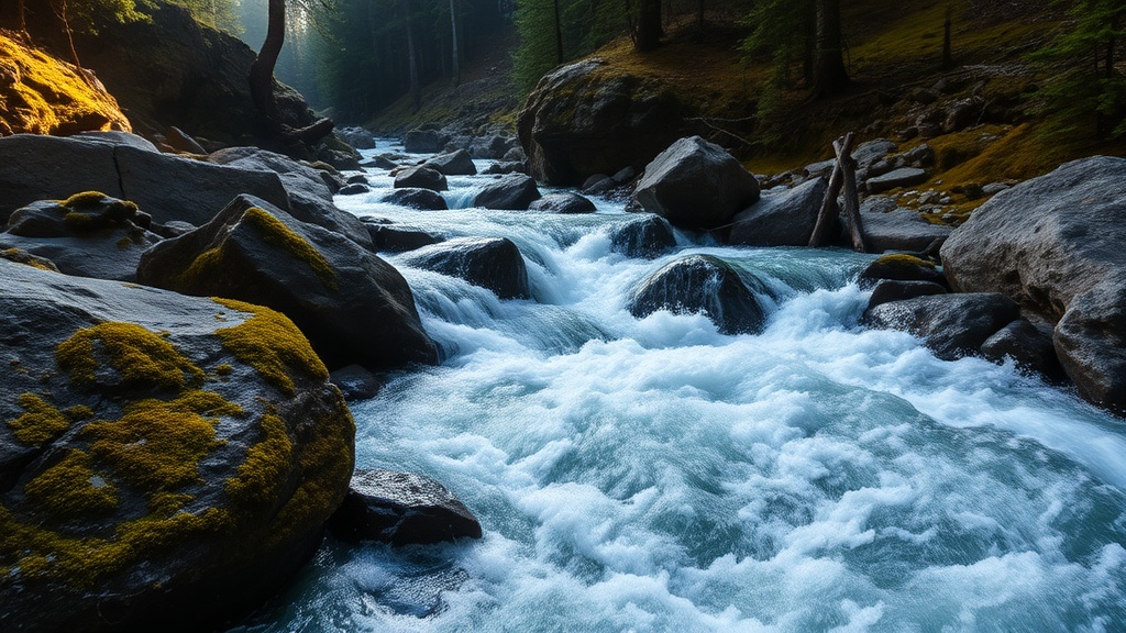
Right now — mid-March — snowpack is sitting heavy in the Cascades. When temperatures start cycling above 50°F at elevation, that snowpack converts to runoff. A creek that was ankle-deep and 4 feet wide in August can be thigh-deep, 15 feet wide, and moving fast enough to knock you flat by late May.
The critical variable is not the creek. It is the timing. A crossing that is manageable at 7 AM can be impassable by 2 PM on the same day because afternoon warmth accelerates melt. I have watched creeks rise six inches in four hours. That is not an exaggeration — I logged it with a stick marker on the Thunder Creek trail in 2023.
## My Pre-Crossing Assessment (Before I Get My Feet Wet)
I run through five checks before I commit to any crossing during snowmelt season:
**1. Depth relative to my knee**
If water is above my knee, I do not cross. Period. The force equation changes dramatically above the knee — your center of gravity is compromised, and the water's leverage against your legs increases exponentially. One hiker on the PCT was found drowned in two inches of water, likely after being knocked down in a deeper section upstream.
**2. Current speed — the stick test**
I toss a stick into the current and pace it along the bank. If the stick is moving faster than I can comfortably walk, the crossing is a no-go. This is crude but effective. You do not need a flow meter. You need honest self-assessment.
**3. Downstream consequence analysis**
Before I look at the crossing point, I look 50 yards downstream. What happens if I fall? Is there a pool I can recover in, or is there a log jam, a waterfall, or a narrowing that turns into a hydraulic? If the downstream consequence is serious, I need a much higher confidence threshold for the crossing itself.
**4. Bottom composition**
I probe with my trekking pole. Cobbles and gravel are stable. Silt, mud, and large smooth boulders are not. Algae-covered rocks in spring runoff are essentially ice. If I cannot feel firm bottom with my pole, I am not stepping in.
**5. Time of day**
Morning crossings. Always. I plan my route so that any significant creek crossing happens before 10 AM. Afternoon snowmelt can add inches of depth and significant velocity. This is non-negotiable in my trip planning from April through July.
## The Actual Crossing Technique I Use
Unbuckle your pack hip belt and sternum strap. If you go down, you need to shed that pack instantly. A 30-pound pack pinning you face-down in moving water is how people die on trails rated "moderate."
I cross facing upstream at a slight downstream angle, using both trekking poles as upstream braces. Two points of contact with the bottom at all times — one pole and one foot move, the other pole and foot stay planted. Shuffle steps only. Never cross your feet.
If I am with a group, we cross in a line abreast, arms linked, strongest person upstream. The upstream person breaks the current for everyone else. This is standard river crossing protocol, and it works.
Bare feet or water shoes. Never cross in your hiking boots. Wet boots mean blisters for the next three days. I carry a pair of $8 water shoes that weigh six ounces. That is the cheapest, lightest safety gear in my pack.
## When to Turn Around
Here is what the trail influencer crowd will never tell you: sometimes the right move is to not cross. I have turned around three times in the last two seasons because a crossing did not pass my assessment. Each time, I drove home annoyed. Each time, I drove home alive.
The North Cascades has a death rate 46 times higher than the combined average for all national parks. Creek crossings during snowmelt are a significant contributor to that statistic. The park service notes that high water can make even seemingly shallow streams dangerous, and not all crossings have bridges.
If your planned crossing fails any of my five checks, you have two options: find an alternate crossing point (wider sections are usually shallower and slower) or turn around. There is no third option where you "just go for it." That third option is how SAR teams spend their weekends.
## The Gear That Actually Matters
- **Trekking poles:** Non-negotiable for any snowmelt-season hike. They are your stability system in crossings and your probe for depth and bottom composition.
- **Water shoes or camp sandals:** Six ounces. Keep your boots dry. Keep your feet protected from sharp rocks underwater.
- **Dry bag for electronics:** Your phone is your emergency beacon. A $5 dry bag keeps it functional if you take an unplanned swim.
- **15 feet of paracord:** Not for building a rope crossing (that requires actual training). For tying your boots to the outside of your pack during crossings so they do not get lost if you drop the pack.
That is it. No gimmicks. No $200 gadgets. Basic logistics applied to a specific problem.
## Plan the Crossing Before You Plan the Hike
When I am building an itinerary for any Cascades hike between April and July, I identify every creek crossing on the route using both the topo map and recent trip reports. I note which ones have bridges and which do not. For unbridged crossings, I check the elevation of the crossing and the snowpack above it. More snow above means more runoff potential.
Then I time the hike so major crossings happen in the morning. If that means a 4:30 AM start, that is what it means. Convenience is not a variable in my safety model.
This is the same approach I used to manage shipping logistics — identify the failure points, build the timeline around them, and have a contingency for each one. Trails are just supply chains where the cargo is you.
## Bottom Line
Spring in the Cascades is not August in the Cascades. The trail you hiked last summer with dry feet and Instagram-worthy crossings may try to kill you in May. Respect the water. Time your crossings. Run the assessment. And when the creek says no, listen to it.
Your ego is not waterproof.